Directional Gyro

The COURSE is of central importance in radio navigation for orientation and is usually determined by the DIRECTIONAL GYRO (see chapter 18.2.3).

So in any radionavigation task, the first thing is to know your own flight direction / HEADING.

  • The compass rose has 360 degrees
  • For simplicity, the compass rose is divided into eight cardinal directions with the corresponding degrees.

It is important to be able to imagine at any time in which compass direction the aircraft is heading. Based on the actual course / COURSE, corrections, counter courses and intercept courses are calculated. This requires a certain mental flexibility.

NDB / ADF

The oldest radio navigation source still in use is the Non-Directional Beacon / NDB. This is a radio beacon that transmits radio waves. In addition, the NDB transmits a Morse code (e.g. TZO), so that it can be clearly identified and another beacon is not accidentally located due to a wrong frequency (analogous to a lighthouse).
The receiver in the cockpit is called Automatic Direction Finder / ADF. The direction from which the ADF receives the signal from the ground station is indicated by a needle on a compass rose.
The ADF is either a stand-alone indicator in the cockpit or it is part of a Radio Magnetic Indicator / RMI, which can receive both NDB and VOR stations. In modern aircraft with glass cockpits, the ADF is always part of the RMI, which is combined with a Horizontal Situation Indicator / HSI in the Navigation Display / ND.

Relative Bearing Indicator (RBI)

The RBI shows the relative angle (relative bearing / RB) between the longitudinal axis of the aircraft and the ground station. Although it is possible to directly determine the position of the ground station relative to the direction of flight, the actual heading is also required to determine the actual line of position.

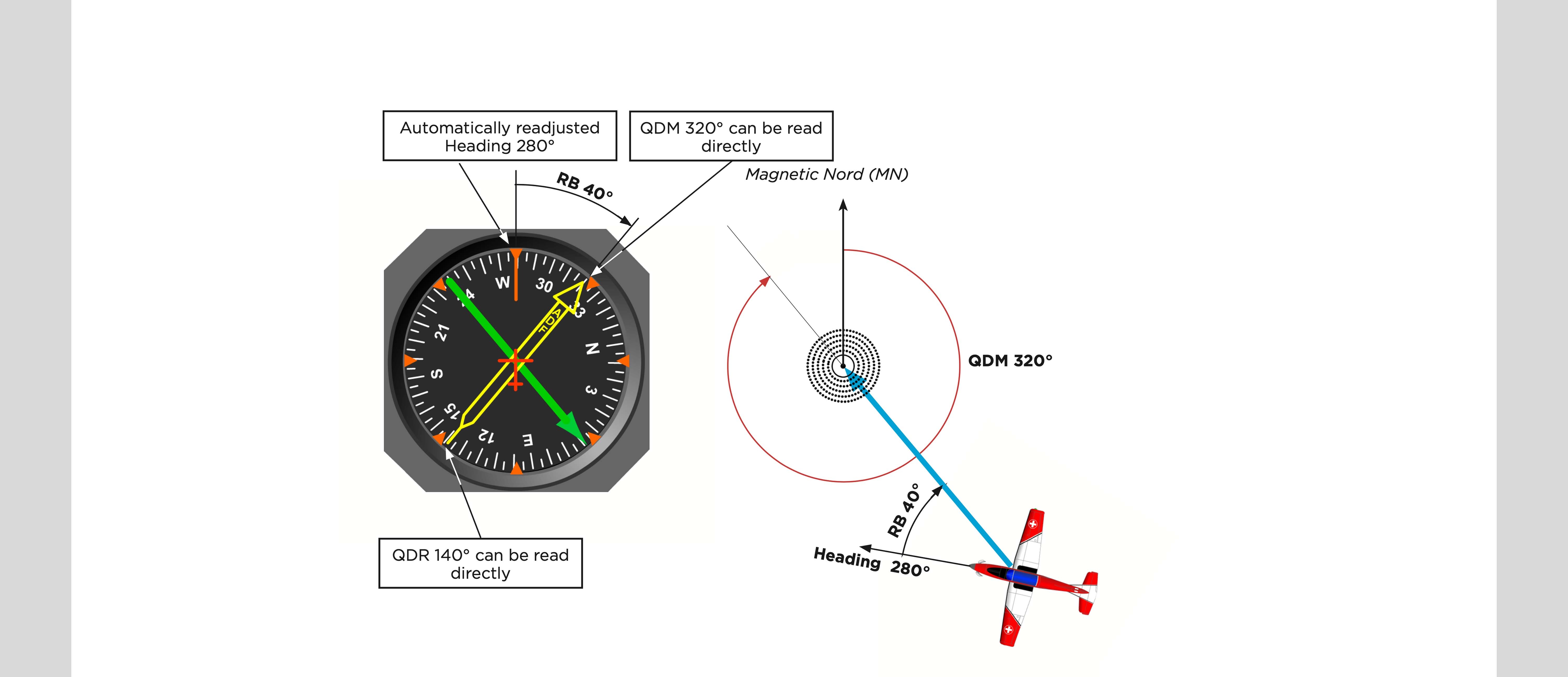
Moving Dial Indicator (MDI)

With the MDI, the scale can be set to the actual heading with a rotary knob. This makes it possible to directly read the actual QDM (tip of the arrow) or the actual QDR (end of the arrow). With this instrument there is an increased risk of reading errors if the heading of the aircraft changes without the MDI being readjusted.

Radio Magnetic Indicator (RMI)

With the RMI, the scale is automatically adjusted as with the directional gyro. In some versions, the direction to two ground stations can be displayed simultaneously. The second can also be a VOR.

Situation in Space

The following illustrations show the position of an aircraft in relation to a ground station and how the situation in the cockpit on the RMI appears when the aircraft flies different headings:

QDR

The term QDR in the Q-code describes in which magnetic bearing FROM the station the aircraft is located.
For this purpose, the compass rose is placed over the station.

QDM

The term QDM in the Q-code describes the magnetic bearing TO the station from which the aircraft sees the station. This is always 180° different from the QDR. For this purpose, the compass rose is placed over the station.

VOR / DME

After the NDB, the rotating beacon «Very high frequency omni directional radio range» / VOR was developed. This is a radio beacon that emits slightly differently modulated radio waves in each direction. This and the higher frequency result in more accurate positioning than with the NDB. In addition, a VOR ground station can be equipped with distance measuring equipment (DME), which allows exact positioning.

Course Deviation Indicator, CDI / Omni-Bearing Indicator, OBI

The indicator in the cockpit is called Course Deviation Indicator, CDI or commonly Omni-Bearing Indicator (OBI). The CDI/OBI is not a bearing indicator; it is a deviation indicator. It indicates the aircraft›s angular deviation from the selected VOR radial or its opposite course.

Course Deviation Indicator, CDI / Omni-Bearing Indicator, OBI

The direction from which the VOR ground station signal is coming can be displayed with a needle on a compass rose, as with an NDB, but is often displayed with a Horizontal Situation Indicator / HSI and is done on the Navigation Display / ND in modern aircraft.

Horizontal Situation Indicator (HSI)

With the HSI, instead of QDR and QDM, we consistently speak of a radial, which is always analogous to the QDR.

Horizontal Situation Indicator (HSI)

For the initial orientation, the Course Selector is rotated until the Deviation Bar is centred. In addition, the TO/FROM indicator is of central importance. Only when FROM is displayed the HSI shows the actual RADIAL.

Horizontal Situation Indicator (HSI)

With the HSI, instead of QDR and QDM, we consistently speak of a radial, which is always analogous to the QDR.

For the initial orientation, the Course Selector is rotated until the Deviation Bar is centred. In addition, the TO/FROM indicator is of central importance. Only when FROM is displayed the HSI shows the actual RADIAL.

Horizontal Situation Indicator (HSI)

In the above example, if the aircraft is east of the VOR and the pilot has set the COURSE to 090, the HSI will give him a FROM indication regardless of his actual heading. His actual radial is therefore 090.

Horizontal Situation Indicator (HSI)

The TO indicator is used to fly towards a VOR.

In the above example, if the aircraft is west of the VOR and the pilot has set COURSE 090, the HSI will give him a TO indication, regardless of his actual heading. However, it consistently speaks of the radial 270°. If the pilot is to follow the radial to the station, he will be told to follow the radial 270° INBOUND.
If it is to follow the radial away from the station, it is referred to as the radial 270° OUTBOUND. The FROM (FR) display is used for this.

Horizontal Situation Indicator (HSI)

Another difference to the RMI (most common display of an NDB) is the Deviation Bar. This shows the angle difference to the selected COURSE (outermost marked display = 10°).

RNAV / GPS / INS

After the VOR, radio navigation capabilities were further developed. Initially through the combined evaluation of VOR/DME signals, later through an Inertial Navigation System (INS) and finally satellite navigation (GPS).

_site.mainFooter

Chapter

Slide / Step /

Your web browser is out of date

Update your browser for more security, speed and the best experience.

Update my browser Continue